About NV Charts GPS Navigation AIS
A clearly structured navigation app with intuitive and comprehensive tools for navigation on board. All current editions of the boating charts or maps from NV Verlag / NV Charts can be easily downloaded and used for...
A clearly structured navigation app with intuitive and comprehensive tools for navigation on board. All current editions of the boating charts or maps from NV Verlag / NV Charts can be easily downloaded and used for offline navigation with the NV Charts App. All latest editions of NV Charts nautical boating charts or inland charts including | North Sea | Baltic Sea | Netherlands | Wadden Sea | IJsselmeer | Sweden | Denmark | Germany | Norway | France | USA | Caribbean | Bahamas areas are compatible with NV Charts App.
One way to have great nautical charts both on paper and on our phone or tablet is to use our popular combination pack of paper and digital nautical charts, which includes both charts in clever atlas format and a license for digital nautical marine boating charts/maps for use in the NV Charts App, including an update service. The advantage: Both your paper and digital charts are up to date.
In addition you can also purchase digital boating charts as a subscription directly in the NV Charts App. The subscription duration is one year and is automatically extended.
If it is not yet clear where the journey is going to take you, free online charts can be displayed in the app, even without a current subscription or valid paperchart edition.
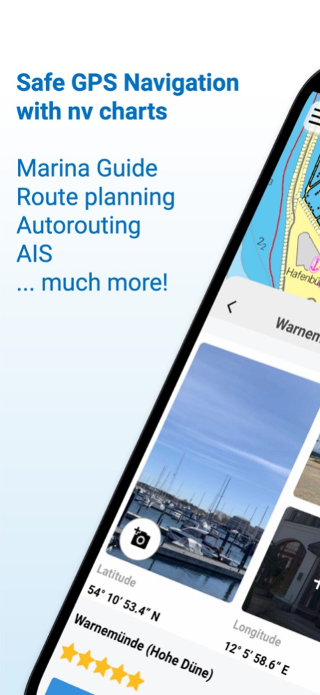
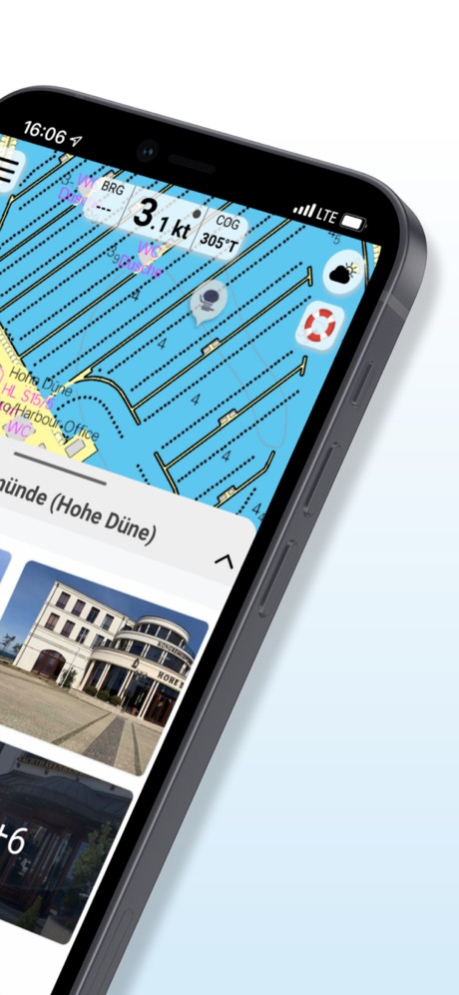
The latest information is essential for safe navigation on the water. With the NV Charts App you have the possibility to become part of the Seame boating community. You can now add marinas, anchorages and navigation warnings to the digital chart and also add and share interesting places beyond navigation, such as restaurants or points of interest with pictures. Others can respond directly with comments. The continuously edited content can be downloaded directly to be available offline. In order to make all information easily accessible, we have improved the search function: You can explore the surroundings and search directly for place names as well as anchorages, harbours, ramps, waypoints, cranes, petrol stations, or tide stations. In addition, an auto-routing function has been integrated, which allows you to navigate directly to your destination.
Together navigation on board is even more fun! You can now share your tracks with friends or use the data outside the app and export it as GPX file. You can share your favorite harbours and anchorages from the app simply by clicking on a link and coordinate your trip planning even better with everyone.
With the AIS function in the NV Charts App you can keep an eye on AIS signals in real-time. You can connect a Wlan AIS receiver to the NV Charts and the app display AIS Class A and B signals and navigation aids (ATON), as well as MOB AIS SART transponder distress transmitters, directly in the digital chart in real-time and the traffic situation can be assessed better.
The NV Charts App can be installed and synchronized on multiple devices.
NV Charts App - Features:
+ Search function
+ Autorouting (Europe + other regions following soon)
+ Velocity Made Good (VMG)
+ Community Layer / Points of Interest(POI)
+ Free online boating charts preview for planning
+ In App Purchases of digital offline charts
+ Community Layer / Points of Interest(POI)
+ Reads all NV Chart chart areas
+ Easy download of the maps
+ Always the latest data
+ Seamless zoom and panning functions
+ Tide Forecast
+ Online weather
+ AIS Wifi Support
+ AIS Sart Beacon
+ AIS CPA function
+ Night mode
+ Anchor alarm
+ Position with GPS
+ Intuitive route planning
+ Course markings, markings, bearing ruler
+ Port information
+ Display of instruments
+ Synchronizing devices
+ Live Position Sharing
+ Social sharing of routes, tracks, positions
Note:
Continued use of GPS in the background can significantly reduce battery life.
Aug 24, 2022
Version 2.709.182
Improved new Vector text rendering
GPS reception display improvements
POI language improvements
Heading and speed filter improvements
Track sharing issues resolved
Size setting for heading line, speed and heading display size
AIS rate of turn display improvements
VMG usage for ETA calculation
Autorouting download management in My Charts
Decimal seperation improvements in settings
Vector Feet / Meter improvements
# 365-day licence with access to all NV Charts App services and functions with paper charts or as in-app purchase
# Let us know what you think:
[email protected]
Previous Versions
Here you can find the changelog of NV Charts GPS Navigation AIS since it was posted on our website on 2022-08-09 00:56:32.
The latest version is 2.709.182 and it was updated on 2024-04-22 09:00:28. See below the changes in each version.
NV Charts GPS Navigation AIS version 2.709.182
Updated At: 2022-08-24
Changes: Aug 24, 2022
Version 2.709.182
Improved new Vector text rendering
GPS reception display improvements
POI language improvements
Heading and speed filter improvements
Track sharing issues resolved
Size setting for heading line, speed and heading display size
AIS rate of turn display improvements
VMG usage for ETA calculation
Autorouting download management in My Charts
Decimal seperation improvements in settings
Vector Feet / Meter improvements
# 365-day licence with access to all NV Charts App services and functions with paper charts or as in-app purchase
# Let us know what you think:
[email protected]
NV Charts GPS Navigation AIS version 2.705.146
Updated At: 2022-05-20
Changes: May 20, 2022 Version 2.705.146
# Autorouting enhancement in calculations and coverage improvements for European waters.
# Internal GPS enhancements.
# Velocity made good (VMG) in expert mode for a better knowledge of the speed to the next waypoint along your route.
# Improved chart update management.
# Overzoom display warning.
# 365-day licence with access to all NV Charts App services and functions with valid edition paper charts or as in-app purchase.
# Let us know what you think:
[email protected]
Disclaimer
Official App Store Link
We do not host NV Charts GPS Navigation AIS on our servers. We did not scan it for viruses, adware, spyware or other type of malware. This app is hosted by Apple and passed their terms and conditions to be listed there. We recommend caution when installing it.
The App Store link for NV Charts GPS Navigation AIS is provided to you by apps112.com without any warranties, representations or guarantees of any kind, so access it at your own risk.
If you have questions regarding this particular app contact the publisher directly. For questions about the functionalities of apps112.com contact us.